| Home | About Us | Email Us | Find It | What's New | Back | Next | |
| VIEWER MESSAGES | ||
|
| MISCELLANEOUS | ||||
|
||||
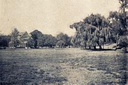 Picture dated c. 1900
Click image to enlarge |
West of Lefferts Boulevard
The tree lined road off to the right is Metropolitan Avenue (then called the Williamsburgh & Jamaica Turnpike). The open field directly in front of the camera is the site of today's Forest and Garden, Alt Green Tower, and Eton Hall Apartment Buildings. The cross street barely visible in front of the distant house is today's 118th Street, then called Church Street. At one time, 118th Street was called Johnson Street - Johnson being the name of a farm at what is today Liberty Avenue between 116th and 124th Streets.
Sources:
- Carl Ballenas and Nancy Cataldi, Images of America - Richmond Hill, p. 12 (Arcadia Publ. 2002)