| Home | About Us | Email Us | Find It | What's New | Back | Next | |
| VIEWER MESSAGES | ||
|
| MISCELLANEOUS | ||||
|
||||
   Click images to enlarge
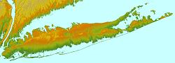
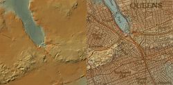
Topographic maps courtesy of Dr. J. Bret Bennington of the Hofstra University Geology Dept.
|
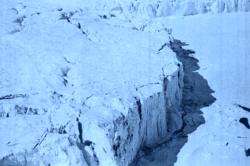
The Terminal Moraine
The beginning was some 23,000 years ago when an advancing glacier stopped at the place we now call Kew Gardens. As the glacier melted, the water ran down to the Atlantic Ocean creating the flat land on which Richmond Hill and other communities to the south were built. The boulders and earth the glacier carried here remained in the form of a hilly ridge that geologists call a "terminal moraine". It was on this moraine that Kew Gardens would be built.
References:
- Barry Lewis, Kew Gardens: Urban Village in the Big City, p. 6 (Kew Gardens Council for Recreation and the Arts 1999)
- William Krooss, A Peek at Richmond Hill Through the Keyhole of Time, p. 5 (1994)
- Vincent F. Seyfried & William Asadorian, Old Queens, N.Y. in Early Photographs, p. v (Dover Publ. 1991).