| Home | About Us | Email Us | Find It | What's New | Back | Next | |
| VIEWER MESSAGES | ||
|
| MISCELLANEOUS | ||||
|
||||
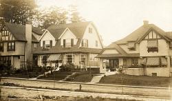 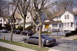 Pictures dated c. 1920 and 2004
Click images to enlarge |
81st Avenue
"[Alrick] Man turned his energies toward developing the outlying Richmond Hill district. Working with his brother [Engineer] Albon [Platt Man, Jr.], he had the land graded (using horse and wagon power in the hilly area) and laid out a road system that curved with the terrain but led as directly as possible into the streets of Richmond Hill, so that the two communities could share 'services and facilities.' . . . The area was subdivided. Each house had more land around it than was allotted to each resident in the original Man development of Richmond Hill."
Sources:
- Quote from: Jeff Gottlieb, "A History of Kew Gardens (Part 3)", The Leader Observer [a local newspaper], (Nov. 20, 1986?) (Bracketed text is mine)