| Home | About Us | Email Us | Find It | What's New | Back | Next | |
| VIEWER MESSAGES | ||
|
| MISCELLANEOUS | ||||
|
||||
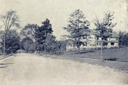 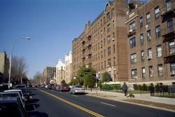 Pictures dated c. 1900 and 2002
Click image to enlarge |
From Brevoort Street
You are standing at the corner of Brevoort Street (formerly Willow Street) looking west on Metropolitan Avenue (formerly the Williamsburgh & Jamaica Turnpike). During the 19th century, Metropolitan Avenue marked the northern border of Richmond Hill proper, and was one of the area's three main early roads - the other two being the Brooklyn & Jamaica Turnpike (also known as the Jamaica Plank Road - today's Jamaica Avenue) and Newtown Road (today's Kew Gardens Road). The circa 1900 picture shows one of the many houses that began to appear around the Richmond Hill Golf Course during the late 1890's/early 1900's as Richmond Hill expanded north from the level terrain around Jamaica Avenue.