| Home | About Us | Email Us | Find It | What's New | Back | Next | |
| VIEWER MESSAGES | ||
|
| MISCELLANEOUS | ||||
|
||||
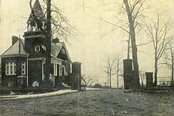  Pictures dated c. 1915 and 2000
Click images to enlarge |
A Man, A Plan, A Canal ...
Sources:
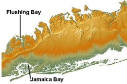
- Topographic map courtesy of Dr. J. Bret Bennington of the Hofstra University Geology Department.
- Walter I. Willis, Queens Borough, New York City, 1910-1920 : The Borough of Homes and Industry, p. 32 (Queens Borough Chamber of Commerce, 1920)
- Research by Diane McClay, Bryans Road, MD
That did not mean that the area would have suffered an open cut like the one later inflicted by the Interboro Parkway. Instead, the portion of the canal running from Union Turnpike and Queens Boulevard to Liberty Avenue in Richmond Hill was to be underground in double reinforced concrete tunnels each having channels 50 feet across with columns between them. The top of each tunnel would have been 30 feet above water level.
State engineers did surveys for the proposed canal in 1913, and a report was made to the Legislature in March of 1914. However, the State never appropriated any money for the project and the idea went nowhere.