| Home | About Us | Email Us | Find It | What's New | Back | Next | |
| VIEWER MESSAGES | ||
|
| MISCELLANEOUS | ||||
|
||||
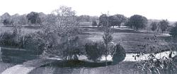 Picture dated c. 1890
Click image to enlarge
ROLE REVERSALS - PART 1
Richmond Hill and Kew Gardens, NY were named after their English counterparts: a London suburb (Richmond Hill) and the neighboring Royal Botanic Gardens at Kew. In England, it is Richmond Hill which occupies the high ground overlooking the Kew Gardens. Here, it is Kew Gardens which sits on the terminal moraine above Richmond Hill. |
A Hill named Richmond
"Richmond Hill" was not just the name of the village to our south, it was also the name of a hill centered between present day Lefferts Boulevard, Metropolitan Avenue and Park Lane South - most likely the hill on which Albon Man first stood. This antique photograph shows the view from Richmond Hill. Local historian, Carl Ballenas, believes the photographer was standing in front of the old Cowles house north of today's today's 117th Street and Curzon Road. We are probably looking southeast at the intersection of today's 118th Street (distant left) and 84th Avenue (distant right). Ironically, the only hills to be found in the village of Richmond Hill were in the area that would later become Kew Gardens. The rest of Richmond Hill was level. Its even terrain was one reason Richmond Hill grew into a community a generation earlier than did Kew Gardens.
Sources:
References:
- Barry Lewis, Kew Gardens: Urban Village in the Big City,
p. 10 (Kew Gardens Council for Recreation and the Arts 1999)