| Home | About Us | Email Us | Find It | What's New | Back | Next | |
| VIEWER MESSAGES | ||
|
| MISCELLANEOUS | ||||
|
||||
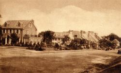 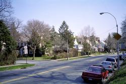 Pictures dated c. 1930 and 2003
Click image to enlarge |
Park Lane South
This is Park Lane South at the intersection of Curzon Road one block south of Mayfair Road. When it opened in 1921, it was called just Park Lane. It runs along Forest Park on the west side of Kew Gardens and is considered one of its main thoroughfares. The part north of Metropolitan Avenue was considered at times as a possible site for P.S. 99 and the First Church of Kew Gardens, both of which were built elsewhere.
Sources:
- The Queens Evening News, [a local newspaper], March 28, 1930
References:
- Barry Lewis, Kew Gardens: Urban Village in the Big City, pp. 17, 32, 35 (Kew Gardens Council on Recreation and the Arts 1999)