Home About Us Email Us Find It What's New Back Next

Search this site - powered by FreeFind                        
PICTURE ALBUMS
In the Beginning
The Long Island Rail Road Station
Maple Grove Cemetery and Vicinity
Kew Cards
Homes of Kew
Lefferts Boulevard and Vicinity
Queens Boulevard and Vicinity
Metropolitan Avenue and Vicinity
Kew Garden Apartments
Kew Gardens in the News
PS99 Photographs and More

VIEWER MESSAGES
Read Guestbook
Post Message
Guestbook Archives
Where Are They?

MISCELLANEOUS
Special Feature
 
Books
Maps
Kew Gardens Improvement Association
Links to Other Web Sites of Interest

CLICK TO ENLARGE.

CLICK TO ENLARGE.

CLICK TO ENLARGE.

CLICK TO ENLARGE.

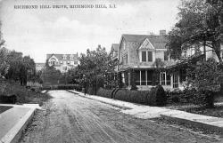
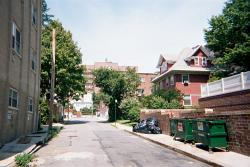
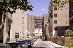
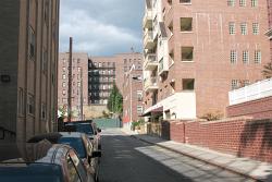
Pictures dated c. 1916, 2001, 2005 and 2007
Click image to enlarge
117th Street

This 1916 printed photograph shows 117th Street (then called Richmond Hill Drive, and before that, Richmond Street) looking north to Curzon Road which is located just south of Metropolitan Avenue. The house on the distant hill is the old Cowles House.

In the 2001 photograph, the red house was all that survived from the 1916 scene where it is mostly obscured by the house in front of it. Sadly, that house, too, has now been razed to be replaced by a multiple dwelling. In 2007, the two houses at the far end of the street were also razed.


Back  |  Next