| Home | About Us | Email Us | Find It | What's New | Back | Next | |
| VIEWER MESSAGES | ||
|
| MISCELLANEOUS | ||||
|
||||
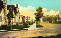 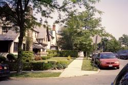 Pictures dated c. 1920 and 2004
Click images to enlarge |
Kew Forest Lane
This street is today's Kew Forest Lane looking east toward Union Turnpike from 77th Avenue. That's Colonial Hall in the distance. The part of today's Forest Hills that is bounded by Union Turnpike, Queens Boulevard, 75th Avenue and Austin Street was developed by the Kew Gardens Corporation, and before the Interboro Parkway came through, it was considered an extension of Kew Gardens.